1. Introduction
Port cities, situated between land and sea where two distinct flow spheres converge, can be described as interfaces linking forelands and hinterlands, creating intercontinental crossroad connections
| [2] | Chaline, C. (Ed.). (1994). Ces ports qui créèrent des villes. [These ports that created cities]. L’Harmattan |
[2]
.
Regarded as “centers of exchange where different cultures and different environments meet”
| [4] | Tan, T.‐Y. (2007). Port cities and hinterlands: A comparative study of Singapore and Calcutta. Political Geography, 26(7), 851–865. https://doi.org/10.1016/j.polgeo.2007.06.008 |
| [9] | Yehuda Hayuth (1982). The Port-Urban Interface: An Area in Transition. Published by: The Royal Geographical Society (with the Institute of British Geographers). |
[4, 9]
port cities are themselves composed of an urban entity and a port entity.
Port city territories include both a global foreland and a deep hinterland. The global foreland comprises international connections that link the port city to other regions worldwide, including trade routes, shipping lanes, and economic exchanges. The deep hinterland refers to the extensive inland areas served by the port, encompassing cities, towns, and industrial zones reliant on it for trade and transportation. Effective governance of these vast and intricate regions demands coordinated management and collaboration among government bodies, businesses, and communities. Beyond physical spaces, this governance must address the logistics of multiple flows—such as goods, people, information, and capital—along with the layered use of space. In these areas, port functions (e.g., docks, warehouses, and transport facilities) often intersect or merge with urban spaces, such as residential, commercial, and public areas. This overlap creates a complex interplay between port and city functions, presenting both challenges and opportunities in urban planning and development.
| [3] | Carola, Hein., (2021). Planning for Porosity: Exploring Port City Development through the Lens of Boundaries and Flows. Urban Planning, 6(3), Article 4663. https://doi.org/10.17645/up.v6i3.4663 |
[3]
The buffer space between the two is defined as the port-city interface
| [1] | Boubacha, E. (1997). L’interface ville/port: Espace- système en mutation, l’exemple de Nantes [The port-city interface: Changing spatial system, the case of Nantes, Postgraduate thesis, University of Nantes]. https://doi.org/10.17645/up.v6i3.4017 |
[1]
. As an intermediary zone, this interface defines the legal boundaries between the city and the port, while also facilitating the integration of urban and port systems and their overlapping interests. Consequently, it becomes a space of both cooperation and conflict, as well as convergence and divergence.
Porosity in port city territories has transformed significantly over time due to changes in logistics, storage practices, urban design, and transportation methods; shifts in political, institutional, and economic structures; and the introduction of new technologies
| [10] | Hoyle, B. S. (1996). Cityports, coastal zones and regional change: International perspectives on planning and management. Wiley. |
| [11] | Hoyle, B. S. (1989). The port‐city interface: Trends, problems and examples. Geoforum, 20(4), 429–435. https://doi.org/10.1016/0016-7185(89)90026-2 |
[10, 11]
. The interactions between various port city stakeholders, including local governments, businesses, maritime companies, and citizens change over time in ways that are visible in spatial, social, and cultural transformations. The geographies of these port regions are thus shaped by several factors that contribute to dynamic changes in their boundaries
| [5] | Krośnicka, K. A., Lorens, P., & Michałowska, E. (2021). Port Cities within Port Regions: Shaping Complex Urban Environments in Gdańsk Bay, Poland. Urban Planning, 6(3), 27–42. https://doi.org/10.17645/up.v6i3.4183 |
[5]
:
1) Technological: Advances in maritime transport and cargo handling methods may give certain port cities an advantage over others;
2) Infrastructural: Development of a certain infrastructure type, which may only be found in specific port cities that constitute a particular functional zone;
3) Economic: Variations in economic conditions can lead to uneven development across different parts of the port area;
4) Political: The establishment of new political entities or politically driven decision-making regarding infrastructure placement can alter the developmental trajectory of the port area;
5) Social: Shifts in trends and emerging new practices may lead to the discontinuation of certain developmental approaches in some regions of the port area;
6) Environmental: The suitability of conditions and available resources, which may influence the decision on where to place new port infrastructure.
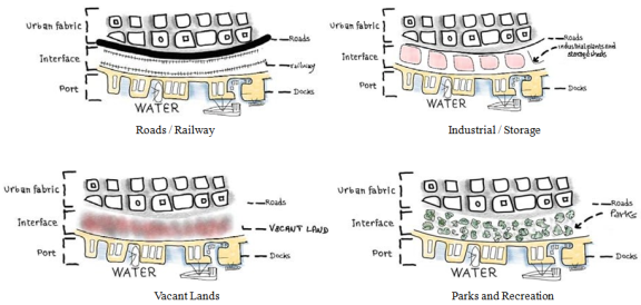
Figure 1. Illustrative diagram of the different spatial split between city and port, with the separating interface as buffer zone.
4. Discussion
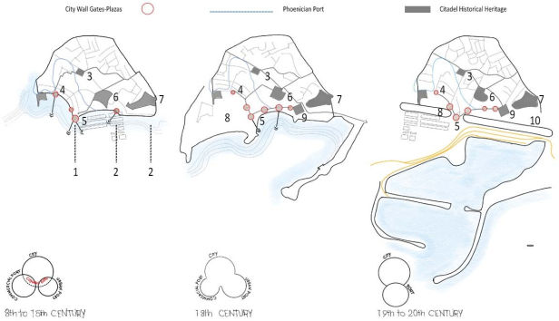
4.1. Case Study of Malaga
The case study discusses the relationship between the city of Malaga and its port over three different periods. The initial phase spans from the 8th century BC to the middle of the 19th century, marked by the demolition of medieval ramparts. The second period is characterized by industrialization, with Malaga being among the rare Spanish coastal cities showcasing significant industrial development
| [7] | Alemany Llovera, J. (1991). Los puertos españoles en el siglo XIX [Spanish ports in the 19th century]. Ministerio de Obras Públicas y Urbanismo. |
[7]
. The last phase, spanning from the late 20th century to today, has been defined by the port's modernization, including the establishment of the container terminal, the cruise terminal, and the renovation of historic port facilities. Ports and cities were functionally and spatially integrated until the 19th century, when ports became industrial, or transit ports and the port-city dichotomy increased. The relationship between the city and port has undergone significant changes in the industrial period. While the demolition of defensive ramparts in the 19th century established a physical connection between the port and the city, the Industrial Revolution brought an “industrial wall” that caused a rupture in this spatial continuity
| [16] | Andrade, M. J., Costa, J. P., Jiménez-Morales, E., & Ruiz-Jaramillo, J. (2021). A city profile of Malaga: The role of the port-city border throughout historical transformations. Urban Planning, 6(3), 105-118. https://doi.org/10.17645/up.v6i3.4189 |
[16]
. Modernization of ports, including the use of steam, revolutionized exchange capacity and sea transport and impacted the morphology and layout of cities. The transformation of ports created both a separation between the city and the sea and socio-economic divisions along the waterfront. On one side of the port, an industrial area with factories and laborer housing emerged, while on the opposite side, a resort area featuring the second residences of the affluent developed. The evolution and advancement of cities during the industrial era were mirrored in their waterfront areas
| [8] | Alemany Llovera, J. (2010). La transformación de los puertos desde la revolución industrial [The transformation of ports since the industrial revolution]. Portus, 19(May), 16–17. |
[8]
. The vacant spaces created by the demolition of ramparts were generally used for port activities, railways that intersected these cities by the waterfront, and even roadways that would later act as barriers between the port and the city. In general, the evolution of ports during the industrial era significantly influenced the layout of the city.
In the post-industrial era, cities reconnected with their waterfronts as integral elements of the urban environment, with ports also recognizing cities as a potential asset for logistics, telecommunications, and tourism.
Throughout these periods, the city-port relationship has shifted from industrial to tourism-oriented activities, with Malaga becoming a hub for beach holidays and a point of reference for cruise tourism in the Mediterranean. The city has implemented urban improvement plans and waterfront transformation to differentiate itself from other coastal destinations, emphasizing cruise ship activity.
The Case of Port of Malaga highlights how cities and ports can have a symbiotic relationship, with the development of the port contributing to the economic growth of the city. However, it also emphasizes the importance of adapting to changing economic and social trends, as the city’s focus shifted from industry to tourism. The case study also shows how urban planning and the restoration of historic areas can contribute to the development of the city’s tourism industry.
The city of Malaga, Spain, reopened its port to the city by implementing an urban regeneration project called Muelle Uno. The project aimed to transform a rundown port area into a vibrant waterfront promenade with shops, restaurants, and public spaces, creating a new connection between the city and the port. Muelle Uno was completed in 2011, and since then, it has become a popular destination for locals and tourists alike. The project included the construction of a modern cruise ship terminal and the renovation of several historic buildings, such as the Customs House and the old Mercado de Atarazanas, which now serves as a cultural center.
Muelle Uno in Malaga is considered a flagship project for the urban regeneration of the city’s port area. The project was designed by the Spanish architecture firm, José Seguí Arquitectos, and was completed in 2011.
The main objective was to connect the port with the city and create a public space that would enhance the quality of life for the city’s residents and visitors. One of the strategies implemented throughout the planning process was the creation of a pedestrian promenade along the port, which allowed people to walk along the waterfront and enjoy the views of the sea and the city. This promenade connects the city center with the port and extends for over 500 meters. Additionally, the project created a public space of approximately 60,000 square meters that includes plazas, gardens, and parks. The project also includes a commercial area with over 90 shops and restaurants, which has become a popular destination for locals and tourists alike. The commercial area is located in a refurbished warehouse that preserves the original industrial architecture of the port. This creates a contrast between the new public space and the historic character of the port. The creation of public spaces has had a tremendous impact on the porosity between the city and the port of Malaga. The project has opened up the port to the city and has created a new space for social interaction and cultural events. It has also increased the value of the surrounding properties and has attracted new businesses and investment to the area.
The Muelle Uno project was designed to integrate the port area with the city seamlessly. The project aimed to create a continuous public space along the waterfront, with pedestrian walkways and bike paths connecting the port to the historic city center. The design also included a network of public transport connections, such as bus and train lines, to facilitate movement between the port and the city.
Overall, the porosity between the port and the city in Malaga has been significantly improved through the Muelle Uno project. The project has transformed a formerly industrial and disconnected port area into a vibrant and accessible waterfront, creating new opportunities for economic development and tourism while reconnecting the city with its maritime history. The project has also provided a model for other cities seeking to enhance the relationship between their ports and urban areas.
4.2. Discussion - Case Study of Beirut
The case of Beirut in 2020 highlighted the need to examine the openness and flow across boundaries instead of enforcing rigid administrative limits. The blast devastating Beirut’s port and city reveals the hidden risks of storing hazardous materials in contemporary ports. The disaster starkly demonstrates that the closeness of a port to its city necessitates coordination, openness, and public engagement. The repeated occurrence of such disasters serves as a constant reminder to seek a proper equilibrium in defining the fluidity of boundaries and the openness of port cities.
Since August 4
th 2020, many local and international experts, academics, and opportunistic developers have viewed the Beirut Port explosion as a chance to reassess critical aspects of urban planning, such as the city's connection to its suburbs, waterfront, and central areas
| [6] | Aouad, D., & Kaloustian, N. (2021). Sustainable Beirut city planning post August 2020 port of Beirut blast: Case study of Karantina in Medawar district. Sustainability, 13(11), Article 6442. https://doi.org/10.3390/su13116442 |
[6]
. The absence of cohesive planning and integrated master plans has resulted in the formation of isolated clusters within the city, with the city center becoming one such cluster, detached from its waterfront. Additionally, the scarcity of public spaces has negatively affected the urban environment, and the urban divide and inequality have only intensified since the explosion, leading to a compounded negative effect on the quality of life in the city
| [6] | Aouad, D., & Kaloustian, N. (2021). Sustainable Beirut city planning post August 2020 port of Beirut blast: Case study of Karantina in Medawar district. Sustainability, 13(11), Article 6442. https://doi.org/10.3390/su13116442 |
[6]
.
The history of urban planning in Beirut is a story of the intersection of colonialism, modernization, and laissez-faire economic policies. During the French mandate period (1920-1943), the city underwent significant changes as part of a modernization effort that aimed to create a European-style city that would serve as a financial center for the region. The French planning approach involved the reconfiguration of existing spaces and the demolition of old souqs and garden houses, leading to a significant transformation of the urban fabric.
The French approach to urban planning in Beirut was heavily influenced by their desire to establish the city as a “Paris of the East,” and this was reflected in the naming of streets and the overall urban design. Despite opposition from local residents, the newly constituted government in 1943 adopted the French planning system, which focused on private development and laissez-faire policies. As a result, real estate developers were given a free hand in the expansion of the city, leading to few new public spaces.
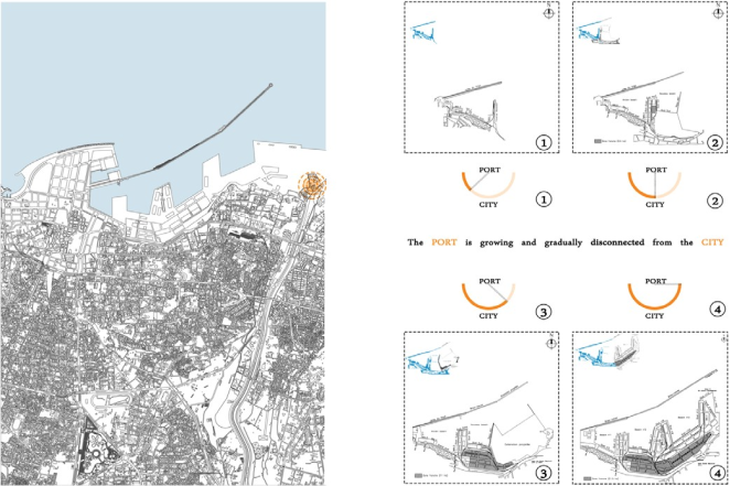
Figure 3. The evolution of the port of Beirut briefly went from being a defense fortress to a center of trade, warehousing and manufacturing. The port of Beirut grew independently and disconnected from the city.
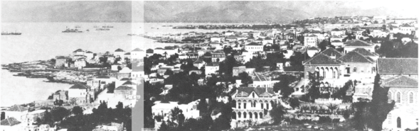
Figure 4. View of Old Beirut and its port. port and City forming one entity.
While some public space names were changed during the French mandate period, most public spaces in Beirut were conceived by the Ottomans and French, resulting in obdurate spaces such as several streets, the Corniche, Sanayeh Garden, Martyrs Square, and Riad el-Solh Square. These public spaces, despite their historical significance, were often neglected and poorly maintained, leading to a sense of detachment from the city’s past.
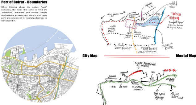
Divided City – Mental and City map
According to Bollens
| [12] | Bollens, S. A. (2012). City and Soul in Divided Societies. London and New York: Routledge. |
[12]
, division, whether it is physical or psychological, can be extremely difficult and can cause intense emotions such as hatred, grief, denial, depression, and forgiveness. The term “polarized” is often used to describe cities that experience significant political, spatial, and social-psychological contestation. While most cities are divided socioeconomically and culturally, polarized cities go beyond that and contain a deeper level of antagonism and opposition.
Furthermore, a fragmented city represents a tangible problem that is embedded within political turmoil
| [13] | Calame, Jon and Charlesworth, Esther (2009) Divided Cities: Belfast, Beirut, Jerusalem, Mostar, and Nicosia. Philadelphia, PA: University of Pennsylvania Press. https://doi.org/10.9783/9780812206852 |
[13]
. Typically, a fractured society will ultimately lead to a segmented urban environment, creating a clear interrelation between social ramification, social inequality, and spatial segregation. Social and economic inequalities can exacerbate inconsistencies and leave vulnerable members of society behind
| [14] | Peter Marcuse and Ronald Van Kempen (Eds.)Of States and Cities: The Partitioning of Urban Space (Oxford: Oxford University Press, 2002). Leonard Nevarez, New Money, Nice Town: How Capital Works in the New Urban Economy (New York: Routledge, 2003). https://doi.org/10.1111/j.0735-2166.2004.0213c.x |
[14]
.
Figure 5. Beirut Divided City- Mental Map.
Bollens
| [12] | Bollens, S. A. (2012). City and Soul in Divided Societies. London and New York: Routledge. |
[12]
suggests that urban planning could play a constructive role in reuniting divided cities. Cities have the potential to bring together divided societies by creating inclusive urban spaces and addressing the underlying social and economic inequalities that lead to division. In this way, cities can help to heal the wounds of a divided society and promote social cohesion.
“Port vicinity neighborhood”
Situated on the outskirts of the port, separated from the Mar Mikhael district by the Charles Helou Highway constructed in 1958, and bordered to the east by the Beirut River, Karantina's urban role has evolved significantly over time. The neighborhood, located within the administrative boundaries of Beirut, was originally named for its function as an Ottoman quarantine station established in the 1830s. By the early 1900s, it had become a hub for rural migrants and workers from neighboring countries. It also served as a refuge for Armenians, Kurds, and Palestinians fleeing the Armenian Genocide of 1915, World War I, and the 1948 Nakba. Over time, Karantina evolved into a working-class district, supplying labor to local industries such as trade, weaving, and handicrafts during the 1960s
.
The construction of the Charles Helou Highway in 1958 had a profound impact on the urban development of Karantina. The highway effectively cut off the neighborhood from the nearby Mar Mikhael area and the rest of the city, creating a physical barrier between the two areas. The highway destroyed many of the buildings in the area, including homes and businesses, and left the neighborhood with a sense of isolation and disconnection.
Before the highway was constructed, Karantina was a thriving hub for trade and commerce in Beirut. The neighborhood was directly connected to the port, which was a major center for trade and transportation in the region. Karantina’s strategic location at the port made it a natural hub for artists, who were drawn to the neighborhood’s dynamic cultural scene.
However, with the construction of the highway, Karantina’s economic activity declined significantly, and the neighborhood became increasingly marginalized and neglected. The physical barrier created by the highway made it difficult for residents to access resources and services in other parts of the city, further exacerbating the isolation and disconnection felt by the community.
Despite these challenges, the residents of Karantina have continued to adapt and evolve over time. The neighborhood has retained its cultural vibrancy, and artists continue to be drawn to the area, even in the face of neglect and marginalization. While the physical isolation of the neighborhood is a significant challenge, the resilience and creativity of its residents continue to drive innovation and progress in the face of adversity. Efforts have been made in recent years to reconnect Karantina with the rest of the city. Plans have been proposed to construct a pedestrian bridge that would span the Charles Helou Highway, providing a direct connection between Karantina and the neighboring Mar Mikhael area. Such a bridge could help to restore the neighborhood’s connection to the rest of the city, providing opportunities for economic and cultural revitalization.
Figure 6. Photographs depicting the deprived waterfront area bordering the port, resulting in unappealing residential neighbor- hoods.
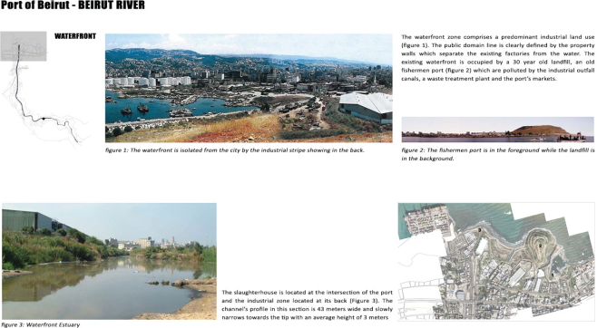
Karantina, today, remains a poor commercial and semi-industrial neighborhood, close to Beirut’s commercial port. It has a population of around 4,638 people most of whom are income poor (ACTED 07/08/2020). In early 2000, a study from Greenpeace found that Karantia was amongst the most polluted neighborhoods in Beirut because of waste-producing industrial sites in the area, a slaughterhouse, and waste treatment plant.
Urban fabric of Karantina - Port
1) High number of unoccupied land parcels.
2) A blend of building types, mostly dominated by large-scale industrial structures.
3) Disorganized, small-scale residential areas with semi-detached houses and many buildings in disrepair.
4) Several properties are designated as heritage sites.
5) Primarily inhabited by lower-income communities.
6) Separated from adjacent neighborhoods.
7) Lacks a clear identity or distinct character.
In recent decades, Beirut's port has continued to function primarily as a hub for importing and storing goods from abroad. It has diminished into a perilous 'warehouse,' a mere shadow of its once vibrant and complex role. Tragically, the port's ominous presence culminated in a catastrophic explosion that wreaked havoc across the city. The silos, which once stood as a symbol of cutting-edge infrastructure and a crucial asset for the nation, now serve as a haunting reminder of its darker side. As we contemplate Beirut's future, we must consider whether relocating the port is a viable option.
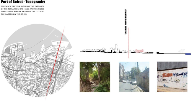
Figure 7. Schematic section showing the rigid inaccessible Barrier between the city and the Port.
Reimagining the port city as a space with new potential involves achieving several key objectives, with a resilient population being essential—one that possesses the mental strength to grasp and adapt to changes. However, it appears that the Lebanese community has chosen a different route towards resilience, resisting any drastic or traumatic changes imposed upon them.
The devastating explosion at the port of Beirut has brought to light the urgent need for reimagining the future of the city. The current state of the port is a dangerous reminder of the neglect that has plagued the city’s infrastructure and urban development for years. The explosion has also highlighted the urgent need for an urban renewal project to transform the port into a functional and thriving space that can serve as an economic driver for the city.
An urban renewal project that integrates green spaces, public parks, and recreational areas into the design of the port can help create a more livable and sustainable urban environment. Such an approach can bring about a much-needed transformation of the area into a vibrant cultural hub that attracts visitors, supports local businesses, and offers a range of recreational and leisure activities for residents.
In addition to these initiatives, an urban renewal program that engages the community can also help to build a more resilient and adaptive population. This approach can involve a range of initiatives, such as job training programs, public education campaigns, and community outreach programs, that help to empower residents and enable them to take an active role in the city’s transformation.
The potential benefits of such an approach are numerous. By transforming the port into a functional and sustainable space, the city can create new economic opportunities for residents and businesses, while also enhancing the quality of life for all. At the same time, a renewed port area can serve as a symbol of the city’s resilience and ability to adapt to change.